A Virtual Hike in the Grand Canyon
Page 2 / South Kaibab Trail - Skeleton Point to Black Bridge
|
|
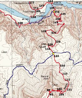
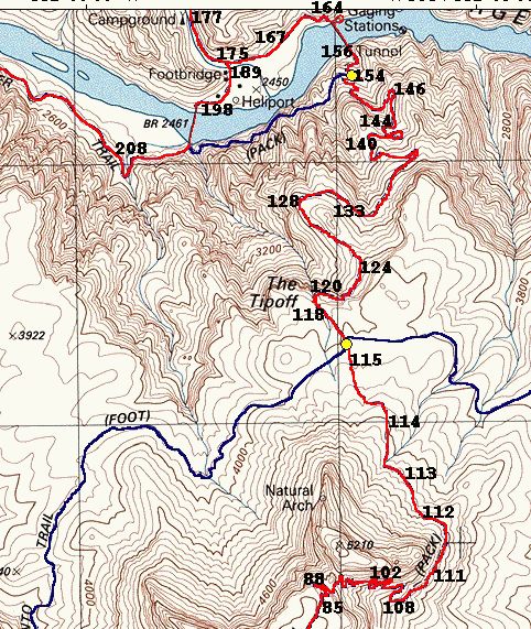
Map 2, Pictures 86-157
The map at the left shows the detailed view of the second part of the
virtual hike. The pictures are numbered to indicate the locations where
they were taken. Most of these locations are fairly accurate, but there
are some that I must admit are just "best guesses."
Click on the map to view it full size.
Click here if you want to see the entire map (957k) showing the entire route with the pictures marked. |


Just beyond Skeleton Point the fairly flat trail goes over what would otherwise be a
cliff, but the trail makes almost a dozen switchbacks to descend this steep
section. The view of these switchbacks is one of the spectacular views on the South Kaibab. These are killers for anyone
attempting a climb up the South Kaibab! If you are doing a day hike and
temporarily ignored the advice of stopping at Skeleton Point, these switchbacks
are an instant reminder: are you sure you want to do this?
This is the first spot on the trail
where you get a look (though just a glimpse) at the Colorado River. For
all practical purposes, Skeleton Point is about the midpoint of the South
Kaibab.
About at this spot we are at the halfway point down the SK.
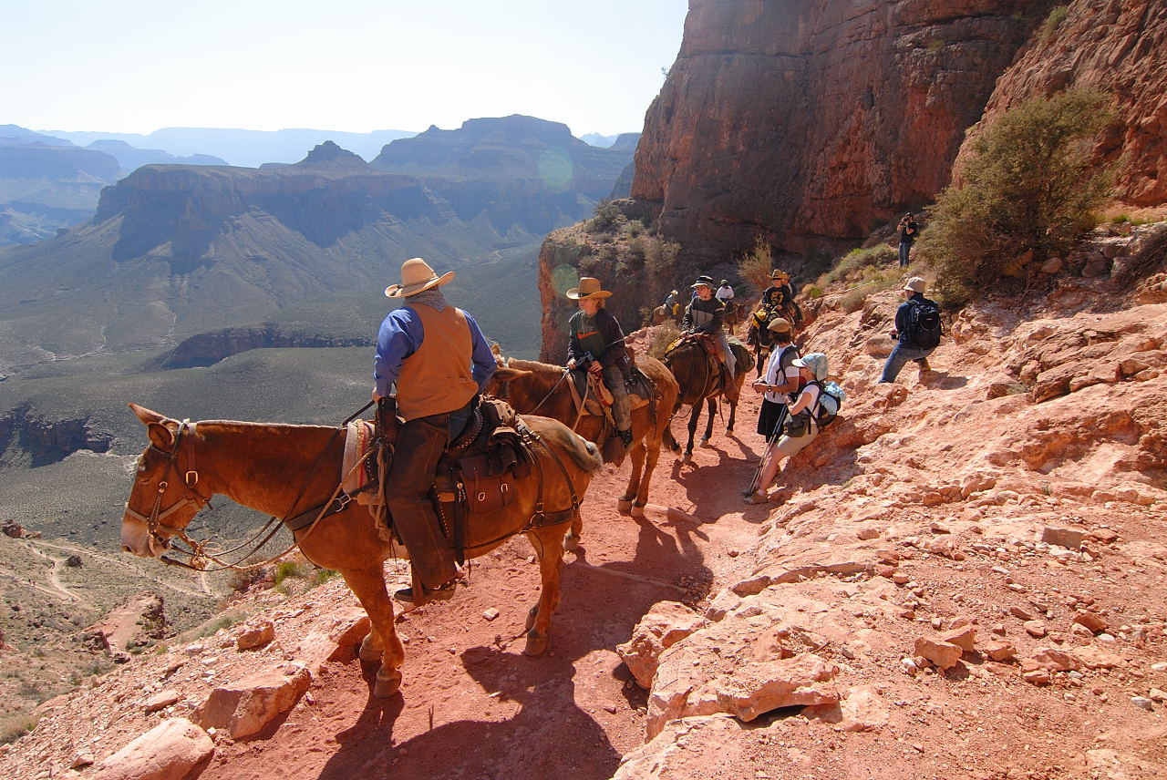
 First mule we encounter on the trail.")


")
The trail's width can be said to be one mule wide! The mules are the
professional climbers on the trails and
they have the undisputed right of
way. Especially when hiking during the morning, you are bound to encounter
mules. On the SK in the morning, I've only encountered them when they're
coming up from the bottom. Take note the mules are always pointing into the canyon when they
stop for safety reasons.
")

")
")
 A look back toward the top of the switchbacks and above that, Skeleton Point.")

Looking back up at the switchbacks you'll notice that they really
blend in.


 part of the trail with me until the tip-off.")
 Looking back at O'Neill Butte.")

")
|
 Another picture looking back toward O'Neill Butte.") In
this picture in the distance you can see the backside
of O'Neill Butte. Even in the close-up view the trail that traverses it is
completely invisible. From this angle it looks like you would fall right
off into the canyon below! In
this picture in the distance you can see the backside
of O'Neill Butte. Even in the close-up view the trail that traverses it is
completely invisible. From this angle it looks like you would fall right
off into the canyon below! |


")

")
When you reach the bottom
of the long switchbacks you've arrived on the Tonto Plateau and the trail
flattens once again. This is the most desolate section of the entire trail.
At the left is the father-son team of Craig & Ben who I passed at this point. Craig wrote to me soon after saying, "You ran past
me and my son a week ago Sunday on the South Kaibab Trail and then stopped
to take a picture and ran backwards while telling us where we could go on
the net to see your photos." Running backward? I'm pretty sure the
park service really discourages this! What kind of fun were they having?
Craig wrote, "Ben and I were having the time of our lives there."


 At the resthouse just before the Tipoff. I lose Josh at this point.")


")

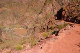
The Tonto Plateau ends
at a point known as The Tipoff. There is a rest house and a hitching post,
but no water. We have traveled 4.4 miles at this point, just over a quarter
of the total distance. What lies just ahead is the inner gorge of the canyon,
also known as Granite Gorge.
As you enter the inner gorge you are greeted with a few of the trail I call
"The Great Arc" as the path makes a 180 degree curve in what really
looks like a half crater. At the end of this big arc which you can see in
the picture at the left is a very special spot called Panorama Point. I
specifically mention this because the actual lookout is some 30 feet off the
trail and easy to miss! I myself missed it on my first two hikes down the
canyon and only found out about it because of pictures posted on the
internet. And do you really want to miss a location they've labeled
Panorama Point?
You will also notice in this picture a path of green in the canyon
below. This is Bright Angel Campground and you'll get a good look at that
from Panorama Point.


")
We have arrived at Panorama Point. Note from this picture that the point is
off the trail and
not marked! The path leading from from the trail
is very lightly worn, an indication that it's lightly visited because most
hikers go right by this spot.
The pictures below show the spectacular bird's-eye view from this lookout
point less than a half mile into the Inner Gorge. The pictures dramatically show
the steepness and you feel (and really are) right on top of the river. If
you have a fear of heights, approach carefully. If you have a severe fear
of heights, you will want to avoid Panorama Point. From here you can see the
trail from Black Bridge to Silver Bridge which you will be traversing
soon. Also visible is Boat Beach, Bright Angel Creek and the Bright Angel
Campground. Phantom Ranch is not visible as it lies beyond the campground
behind the mountains.


")

As you can probably tell from the photos, the trail in the Inner Gorge
is a fine reddish dust that gets on your shoes and socks. Visitors taking
the mule trip on this part of the trail often dawn their handkerchiefs.
This part of the trail can feel pretty lonely, especially in the early morning
when it is still in the shadows. Also, for the first time you'll also appreciate
the shadows when you get them. If it hasn't felt warm, that feeling will
begin when you hit the Inner Gorge.


 Looking west toward Silver Bridge.")


Just before reaching the tunnel that will lead you onto Black Bridge, you
pass the River Trail turnoff. You could turn left at this spot and get
over to the Bright Angel Trail, but I don't think many take this option because
just a little farther down and you're at the river. For me the South
Kaibab Trail ends when you arrive on Black Bridge although it technically it
doesn't until you hit the Bright Angel Campground.
If you'd like a full-sized slideshow, click on any of the images which
will take you to my Google site and launch a slideshow. Note: this slideshow
isn't mobile-friendly. If you like to go to the Google page for the
pictures,
click here.
We've arrived at the river, but still 4 more pages to complete the entire tour. To continue on hit next.


 First mule we encounter on the trail.")


")
")

")
")
 A look back toward the top of the switchbacks and above that, Skeleton Point.")


 part of the trail with me until the tip-off.")
 Looking back at O'Neill Butte.")

")
 Another picture looking back toward O'Neill Butte.")


")

")
 Craig & Ben, \"Having the time of our lives\"")


 At the resthouse just before the Tipoff. I lose Josh at this point.")


")


")
 Standing at Panorama Point. This shows you how far you have to go off the trail.")


")


 Looking west toward Silver Bridge.")


